 Rugged
Mountain
Rugged
Mountain
Northern Vancouver Island
Rugged
Mountain
Northern Vancouver Island
Information about Rugged Mountain:

A place to camp:
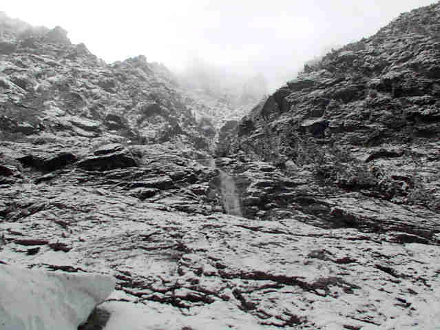
We made camp just a little bit before the land-slide you see in the picture on top. The land-slide took out the road, so you can't go passed it. It was a nice place to make camp because we knew there wouldn't be anyone coming up that far. I think most people that live up there know that the road ends so they probably don't tend to go that far. It was obvious from a fire pit and benches that other people had camped there before.
Rugged Mountain is highly populated with bears, so you're going to have to be careful when hiking in that area. All precautions should be taken to avoid bears like putting your food up in a tree (or somewhere the bear can't get to it like a vehicle), and makes lots of noise when hiking or out in the forest.
If you decide to hike up with your pack, there's a place to camp about an hour and half away. There's a fire pit there and a bench, but if you go out during the winter, don't look for that because you probably won't find it. It's an open area, and I believe there's a pile of wood beside it. Of course, you can pretty much camp wherever you think is a good place to camp.
Where to start hiking:
N20 is the road you need to look for, it's the start to go up Rugged Mountain, the only problem is that N20 isn't marked, and isn't in very good shape. The road is not drivable no matter what you drive, or how good of a driver you think you are. There is a land-slide a little ways up N20, so there isn't any point of trying. N20 is the road after the waterfall, and before the first bridge. If you go down the road, you will pass two bridge, if you do, then you know you have passed N20. Going up N20 is easy on foot, but there's a lot of big alder trees that you need to walk through. It isn't very fun, but it doesn't last the hole way. You will hit two long switch backs on N20, and after the switch backs, there will be an open area with a road blocked by big boulders, and one road going up. You want to take the road that the boulders block. You can see blue ribbons, just look for those. Follow that road, it isn't nice at all, worse then N20, but it does the job. The road will end, and then you will have to decide wish way you want to go, we followed a dried creek bed up to the first small ice field you see. We didn't go up any further than that because the weather was bad, and it was getting late. Proper gear is VERY necessary, head-light, warm clothing, food, water are all important things to have. Some climbing gear might be needed if you want to go right to the top. We brought our ice axes and snow-shoes with us, I also had an avalanche shovel. Avalanches are very common on Rugged Mountain and should be really watched out for.
Here's a good little map to print out to bring with you. It has
some information that will be useful out there. Map
of Rugged Mountain/Nomash River area
For more information, contact Mike at: my_arm_is_on_fire@hotmail.com
or
Dave at: i_am_kaboo@hotmail.com